[News Culture] In the mountains of Yeongwol, centuries of human history sit alongside a landscape shaped over hundreds of millions of years. Ancient limestone formations lie beneath the ground, while higher in the hills, a quiet village still bears the marks of a coal mining industry that once brought thousands of people to its narrow streets. Untan Godo 1330 Course 2 brings these contrasting histories together on a walking route through the countryside of Gangwon Province.
Known as the "Winding Road of Kim Sat-gat's Slow Footsteps," the trail takes its inspiration from the wandering poet who spent much of his life traveling through Korea. Beginning at Gossigul Cave, it passes through Neulbo Village, Okdong and Yemilchon before reaching Moun-dong, a former mining settlement tucked into the mountains. Along the way, rural landscapes, local winemaking traditions and the remains of a once-thriving industrial community reveal different chapters of Yeongwol's past.
Gossigul Cave and the Story Written in Limestone
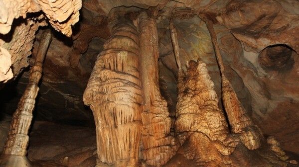
The journey begins underground at Gossigul Cave, one of Yeongwol's most significant natural landmarks. Its limestone dates back roughly 400 million years, to a time when the geological foundations of the region were taking shape. Over a much longer sequence of geological processes, water seeped through fractures in the rock, gradually dissolving the limestone and carving out the cave's passages.
The cave also carries a story from Korea's more recent past. According to local tradition, members of the Go family sheltered here during the Japanese invasions of Korea in the late 16th century. The family's surname became part of the cave's name, connecting the underground landscape with a period of war and displacement.
Designated Natural Monument No. 219 on June 4, 1969, Gossigul is known for its variety of limestone formations. Stalactites descend from the ceiling, stalagmites rise from the floor, and columns form where the two meet. Cave coral and other mineral deposits add to the geological diversity, created as calcium carbonate dissolved in groundwater gradually accumulated over time.
Yet Gossigul is more than a collection of unusual rock formations. Its dark, relatively stable underground environment supports organisms adapted to conditions very different from those above ground. Among the species recorded here are members of the unusual insect group known as grylloblattids, or ice crawlers.
The combination of geological formations and specialized cave life makes Gossigul an important site for understanding both the region's natural history and its underground ecology. For hikers setting out on Course 2, it offers a striking introduction to the landscapes that lie ahead.
Village Roads, Vineyards and the Rhythm of Rural Yeongwol
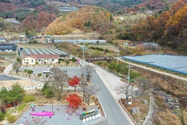
Beyond Gossigul, the trail moves into the rural communities of southern Yeongwol. The first is Neulbo Village, where fields, village roads and surrounding hills establish a quieter pace for the walk.
The route's association with Kim Sat-gat feels particularly fitting here. Rather than following a succession of major tourist attractions, hikers travel through working villages and agricultural landscapes, encountering places shaped by generations of local residents.
Okdong is known for its vineyards, where grape cultivation has become part of the area's agricultural identity. The mountain climate and local growing conditions support a farming tradition that continues to influence the village economy. Walking past cultivated fields and modest homes, visitors get a closer view of rural life beyond Yeongwol's better-known historical sites.
The next stop, Yemilchon, has built on that agricultural heritage through wine production and visitor experiences. Local grapes are used to produce wine, while the village's tourism programs introduce travelers to a different side of the region's food culture.
At the Yemil Healing Wine Center, visitors can combine a wine experience with a relaxing foot bath. It is a distinctive stop on a route otherwise dominated by walking, offering an opportunity to rest before the more demanding mountain section ahead.
Yemilchon also reflects how some rural communities have expanded beyond agricultural production by developing food processing and tourism activities. For visitors, these businesses provide opportunities to experience the local economy rather than simply passing through the landscape.
After leaving Yemilchon, the trail becomes more strenuous. The road climbs toward the slopes of Mangyeongdaesan Mountain, gaining elevation as it approaches Moun-dong. The transition is noticeable: agricultural fields gradually give way to steeper mountain terrain, valleys and forested hillsides.
This final ascent calls for a steadier pace and some attention to energy levels. The climb, however, also marks the beginning of the most historically distinctive part of the route.
Moun-dong, Where the Clouds Gather Over a Mining Past
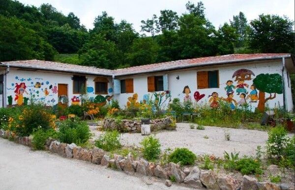
High in the mountains lies Moun-dong, a village whose name evokes clouds gathering over the hills. Mist frequently settles around the slopes after rain, sometimes leaving the settlement surrounded by a blanket of cloud.
Today, Moun-dong is a quiet mountain community with colorful murals painted across the walls of its houses. Its peaceful appearance, however, conceals a remarkable industrial history.
In 1954, the opening of the Okdong coal mine transformed the village. Miners and their families arrived from across the country, drawn by employment opportunities in an industry that was becoming central to South Korea's developing economy.
At its peak, Moun-dong reportedly had a population approaching 10,000, with some 2,000 miners working in the area. Houses spread across the steep hillsides, and a busy commercial district emerged to serve the growing population.
Markets, restaurants, tailor shops and even a movie theater operated in this remote mountain community. The scale of the settlement reflected the importance of coal production at a time when mining towns supplied fuel for South Korea's industrial expansion.
Coal extracted from the Okdong mine was transported by aerial ropeway to storage facilities near Seokhang Station, where it entered the railway network. The connection linked a secluded mountain village with the country's broader energy supply system.
For decades, the mine determined the rhythm of everyday life. Employment, commerce and the community's growth were closely tied to coal production. What is now a quiet rural settlement was once a place of considerable industrial activity.
That era ended in 1989, when the Okdong mine closed amid the decline and restructuring of South Korea's coal industry. Jobs disappeared, families moved away and the businesses that had supported the mining population gradually shut their doors.
Moun-dong experienced the same economic and demographic pressures that affected many former coal mining communities. The village's decline left behind buildings, streets and memories of a period when the surrounding mountains were filled with industrial activity.
In the years that followed, residents began finding new ways to preserve and revitalize their community. Murals appeared on house walls, transforming ordinary village lanes into an outdoor gallery and attracting visitors interested in the area's history.
The paintings have become a defining feature of present-day Moun-dong. They offer more than a colorful setting for photographs, reflecting efforts by the remaining community to give an old mining village a new identity without losing sight of its past.
Walking through the village today, visitors encounter traces of both eras. The steep streets and settlement layout recall the mining boom, while the murals speak to the community's attempts to adapt after the industry disappeared.
One Trail, Many Chapters of Yeongwol's History
Untan Godo 1330 Course 2 brings together places that might otherwise seem unrelated. At Gossigul Cave, the story begins with ancient limestone and the geological forces that shaped the land. In Okdong and Yemilchon, it moves into the agricultural traditions and contemporary rural economy of Yeongwol. The final climb to Moun-dong reveals the legacy of coal mining and the changes that followed its decline.
The route also offers a physical sense of these transitions. Village roads give way to farmland and vineyards before the trail climbs into more demanding mountain terrain. The landscape changes alongside the history, making each section feel distinct.
For hikers interested in Korea's rural and industrial heritage, the journey offers something beyond mountain views. The places along the trail show how communities have adapted to their surroundings, whether through farming, mining or tourism.
Moun-dong provides a particularly revealing conclusion. What was once a prosperous coal town has become a small mountain village, its history still visible in the streets and buildings that remain.
Following a trail named for Korea's wandering poet, travelers encounter the geological past, rural present and industrial memory of Yeongwol, discovering how much history can be found along a single mountain road.
Reported by News Culture M.J._mj94070777@nc.press
Copyright ⓒ 뉴스컬처 무단 전재 및 재배포 금지


